


Fewa Tal (Lake)
The lake in the immediate vicinity of the city is the Fewa Tal with an island temple dedicated to Goddess Barahi in the middle. With its serene water reflecting the Annapurna Range and nicely reserved woods on the adjoining southern slope, this legendary second largest lake of the kingdom is indeed a source of attraction for the visiting tourist. This lake can also be enjoyed by swimming and boating.
Begnas Tal & Rupa Tal (Lake)
These twin lakes lie to the north-east of Pokhara Valley about 15 kilometers away from the airport. The road to Beganas follows Kathmandu-Pokhara Highway (the Prithbi Highway to some) as far as Sisuwa near the police check post and branches off the road towards north. It is possible to fetch a bus-ride to the damside of Begnas from the city. A small hill called Pachbhaiya which separates the two lakes can be reached in 30 minutes on foot from the Begnas bus stop. From a convenient point on this hill one can overlook the twin lakes on either side. These two lakes provide an opportunity for angling, canoeing, sun-bathing and bird-watching.
Mountains
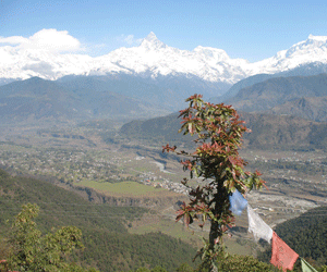
The moment you step into any part of Pokhara the first thing that takes you to a spontaneous delight is the gorgeous view of the gigantic mountains.
Pokhara is, in fact, the first and foremost convenient point for mountain-oriented sightseeing. Mt. Annapurna, literally meaning the Goddess of Abundant Harvest, lies at a horizontal distance of 40 kilometers from the valley of Pokhara which remains at an elevation of just 900 meters above the mean sea-level. Here is a clear clue for the identification of mountain peaks visible from Pokhara. At the extreme left isolated from the massif is visible the peak of Mt. Dhoulagiri (8,167 m.). In order to have a clearer view of this peak, however, it is advised to proceed to the south-east direction of the valley past the airport. On the extreme left of the massif, the bumpy peak in the foreground is Annapurna South (7,219 m.). A little beyond the South Peak in the background lies Annapurna I (8,091 m.). The most imposing pyramidal peak in almost central fore-ground is Mt. Machhapuchhre (Fish-Tail 6,997 m.). Slightly east and back of this peak lies Annapurna III which almost looks like the back of a camel.
Between Annapurna III (7,556 m.) and the nest mountain with a characteristic rocky right flank which is Annapurna II (7,937 m.) lies Annapurna IV (7,535 m.). Separated from the main massif of the Annapurna, one mighty mountain appears on the right; Lamjung Himal (6,983 m.). Finally in the east Manaslu and Himalchuli can be well spotted. For a long panoramic view of the mountains from Dhoulagiri in the west to Ganesh Himal in the distant east, you can drive as far as Titunga behind the Institute of Forestry, Ram Bazaar in the south-eastern part of the Pokhara Valley. This view point can also be approached from Pokhara airport by heading south-east parallel to the narrow gorge of the Seti River and finally crossing the river over a natural stone bridge called Dhungesanghu on the left side of the Mahat Gaunda village
Mahendra Cave
It is another interesting natural site across the Seti River past Batulechour village in the north of Pokhara Valley. It is one of the few stalagmite-stalactite caves found in Nepal. The cave has not yet been fully explored and it conceals more than the present first galleries. A flashlight is worthwhile to explore the interior.
Sarangkot
Bindabasini Temple along a ridge road to Sarangkot. Annapurna range and overlook the valley of Pokhara to enjoy the eye fast of the east. A view tower has been built on the top of Sarangkot hill at an elevation of 1,600 meters.
![]()
![]()
![]()
![]()
![]()
![]()
![]()
![]()
![]()