


The Annapurna Circuit Trekking route encircles the Annapurna Range, a collection of massive, snow-covered summits, many over 26,000 feet. While walking on the Annapurna circuit trekking route, you will encounter 17,000-foot passes, glaciers, the world's deepest valley, pine forests, rice paddies, tundra, remote villages, and ancient monasteries. Most trekking start up the Marsyandi River, then continue north in the wooded Manang Valley through Chamje, Pisang, and Braga (or other villages in the valley). You must take your time initially, getting used to the elevation. Midway through the trekking, you will encounter 17,771-foot Thorong La Pass, one of the most formidable passes in Annapurna Circuit Trekking. It may sound crazy to suggest starting up the pass in the middle of the night, but when you clear the pass at daybreak, the reward for your questionable sanity is a breathtaking view of the world's tallest mountains glowing in the pastel light of dawn. Also the weather at pass is not so good in late afternoon.
On the other side of the pass, it is a steep descent to the Hindu and Buddhist shrines at Muktinath (12,500 feet). From there, you pass through the Kali Gandaki Gorge, a rugged valley three times as deep as the Grand Canyon. As you descend the Kali Gandaki towards Pokhara, there are continuous views of 26,796-foot Dhaulagiri, and other 20,000 peaks in the Annapurna. Take time to enjoy the view, as Pokhara is the last stop on the Annapurna Circuit Trekking before returning to Kathmandu.
| Itinerary in Detail | |
| Day 01 | Arrival in kathmandu Upon arrival at Kathmandu International Airport transfer to your hotel in Kathmandu or Bhaktapur. A short briefing will follow concerning the necessary formalities and your Annapurna Circuit trek itinerary. Depending upon your arrival time you may spend free time visiting nearby sanctuaries or resting. |
| Day 02. | Sightseeing / Cultural Day in Kathmandu Valley Half day sightseeing around UNESCO Bhaktapur / Kathmandu where your guide will escort you on a tour of Buddhist and Hindu temples and shrines reflecting ancient local traditions. There is time to explore the city’s many places of interest on your own or take a rest while trekking permits are finalised. In the evening sample a delicious traditional Nepali dinner. Overnight in Kathmandu. |
| Day 03 | Kathmandu to Dharapani via Besisahar Driving about 9 hours (760m, 2493ft) After your early breakfast, Our guide will pick you up from your hotel and take you by bus to Besisahar. We will begin this journey by driving along the Kathmandu-Pokhara Highway to Dumre, then along the Marshyangdi River on a rough road. The road from Kathmandu to Besisahar is It takes approximately 5 hours. We will be stopping for Lunch at Besisahar and then catch up a sharing Jeep towards to Dharapani or at least to Jagat. Over night at trekking lodge. |
| Day 04 | Dharapani to Chame takes about 6 hours trekking ( 2670m ,8759 ft ) The trail leads to the west of the Manaslu Himalaya, with superb scenery of Annapurna II, which appears infrequently to the south. As we proceed, the Annapurna Range provides a spectacular view of the Annapurna Range. Today's destination will take approximately 6 hours, overnight at trekking lodge. |
| Day 05 | Bahundanda to Chamje (1410m) We start the day by descending on a steep slippery trail past amphitheatre-shaped rice terraces. There will be a small hot spring after this descend. The rest of today’s trek will have us pass the river a few times and we will see a few waterfalls as well. As we near the village of Jagat we will have a steep 200m climb to a trail that has been blasted out of the rock face. 15 minutes below this village we can visit another small hot spring. From Jagat we climb up to Chamje (6 hrs). |
| Day 06 | Chamje to Bagarchhap (2160m) Today we will do the 940 meter ascent to Bagarchap through bamboo and rhododendron forests, on a trail high above the river bank. We will pass the village of Tal at 1700 meter which lies at the foot of a large waterfall. The trail crosses a broad, flat valley that was once a lake (Tal means lake) after which we will cross the Marsyangdi by a 60 meter long suspension bridge. The trail will climb up from a second suspension bridge to a stone kani (an arch over the trail) which marks the entrance to Dharapani at 1960 meter. All old villages from here to Kagbeni have these arches and they become more elaborate and picturesque as the Tibetan influence becomes stronger. The trail slowly climbs from here on through a forest of blue pine, spruce, hemlock, maple and oak to Bagarchhap. This is the first village on the trek with typical Tibetan architecture: closely spaced stone houses, with flat roofs piled high with firewood. (7 hrs). |
| Day 07 | Bagarchhap to Chame(2170m) We will first follow the south bank of the river climbing to Syal Khola (the river of jackals) at 2210 meter, after which we will cross the river over a cement bridge near a spectacular waterfall. The route crosses several landslides as it works its way uphill through a walnut tree forest and aside apple orchards until we arrive at Chame. At the entrance of the village is a long wall with many prayer wheels. Throughout the day there are nice views of Lamjung Himal, Annapurna II and Annapurna IV (7525m) (6 hrs). |
| Day 08 | Chame to Pisang (3190m) We will first pass the older part of Chame and climb up to Telekhu at 2840 meter and continue with a long pleasant and mostly level walk through the forest to Brathang, which lies at 2950 meter. After the trail rounds a bend here we will see the first view of the dramatic Paungda Danda rock face, a tremendous curved slab of rock rising more then 1500 meter from the river. We will cross back to the south bank of the Marsyangdi on a suspension bridge at 3080 meter and then make a long gentle climb over a ridge through blue pine forests. After this the trek will be reasonably level as it heads to the upper part of Manang valley to Pisang. This town marks the beginning of the region known as Nyesyang, the upper portion of the Manang district (5 hrs). Tibetan house |
| Day 09 | Pisang to Manang (3540m) Today our trek will slowly climb up to the Tibetan-style village of Bryaga at 3500 meter following the valley floor. At Bryaga we will see houses stacked one atop the other, each with an open veranda formed by a neighbour’s rooftop. The gompa, perched on a high crag overlooking the village, is the largest in the district and has an outstanding display of statues. We then continue through a very arid countryside, dominated by weird cliffs of yellow rock, eroded into dramatic pillars alongside the trail to reach today’s destination, the village of Manang, where the shops are surprisingly well stocked with all the things you might want to refuel on (5 hrs). |
| Day 10 | Manang. Today we stay in Manang where we can do a short hike to ascent slightly higher to for instance Khangsar, which is a 200 meter ascend. It is important to have a relatively restful day today, to allow your body to acclimatize to the higher altitudes and thinning air. It also gives us the possibility to wash some of our clothing. |
| Day 11 | Manang to Letdar (4250) Trekking slowly upwards to Thorung La we will leave the large trees behind and see vegetation consisting mainly of scrub juniper and alpine grass and we will pass a few meadows where horses and yaks graze. After we reach Yak Kharka we will see herds of blue sheep grazing the steep slopes as well. About an hour after passing Yak Kharka we will arrive at Letdar (4:30 hrs). |
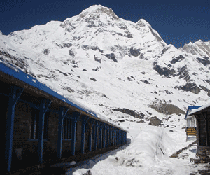
| Day 12 | Letdar to Thorang Phedi, or Thorang High Camp Again a relatively easy day to get used to the altitude before we have to cross the highest point in the trek, and possibly the highest point you have been on in your life. From Letdar we will continue to climb along the east bank of the Jarang Khola to Thorung Phedi, a rock-strewn meadow surrounded by vertical cliffs at 4420 meter. Blue sheep and even snow leopards can be sometimes seen in this valley. High in the skies above us we can see lammergeyers and Himalayan griffons circling around (3-4 hrs). |
| Day 13 | Thorang-Muktinath (3800m) via Thorang La Pass (5416m) Today is a long trek starting before sunrise at maybe 04:00 hrs to reach the pass by 09:00/10:00 hrs at the latest, as otherwise weather conditions will greatly affect the journey. We cross over at an altitude of 5416m so can be exposed to strong winds if crossing too late. Local people have used this trail for hundreds of years to bring herds of sheep and yaks in and out of Manang. Thus the trail, while often steep, is well defined and easy to follow. Snow can block the pass at any time of the year if there has been an unseasonable storm. It takes from four to six hours from Thorung Phedi to the pass, but the many false summits mean the climb seems to go on for ever. At the Thorung La pass, with its traditional prayer flags and stone cairn we will have outstanding views. You can see the Annapunas, Gangapurna and Khatung Kang, a heavily glaciated peak. Amazingly there is a teashop here on top of the pass at 5416 meter. From here we start a long descend of about 1600 meter with outstanding views of Dhaulagiri mountain standing alone in the distance across the valley. After the trail becomes less steep we will enter grassy fields and cross meadows to our final destination of Muktinath, which means place of Nirvana and is home to the Muktinath temple as well as several monasteries. It is said that all sorrows you feel are relieved when visiting the Temple, which is a scared pilgrimage site to both Hindus and Buddhists. The main pilgrimage normally takes place in September. The Temple is dedicated to Lord Vishnu and has 108 waterspouts around it from which Holy water pours. Another attraction nearby is the Jwala Mai Temple and this contains a spring and an eternal flame fed by natural underground gas (9 hrs). |
| Day 14 | Muktinath to Marpha via Jomsom (2665m) From today we will follow the “Jomsom trek” in reverse order. We will first make a 990 meter descent through meadows, streams and fruit orchards down to Kagbeni, a fascinating medieval village infused with Tibetan culture. Then we will continue going down the Kali Gandaki gorge to Jomson (more correctly Dzongsam, or “new fort”). |
| Day 15 | Jomsom to Pokhara Fly to Pokhara and spend the day at leisure, relaxing, and maybe enjoying a massage or enjoy sightseeing around Pokhara valley. Overnight in Pokhara. |
| Day 16 | Pokhara to Kathmandu Tourist bus to Kathmandu. Overnight stay at hotel. |
| Day 17 | Kathmandu Departure from Kathmandu. |
| Price: USD1300 P/P (Single Supplement USD 200) | |
| Price includes: | Airport Pick up/drop, 3 nights accommodation in kathmandu & 1 night in Pokhara at tourist standard hotel, sight seeing in around kathmandu valley by private vehicle and a professinal city guide, all inclusive trek such as Ground transportation, necessary permits entrance fess, professional guide, porter/porters, and their expenses including their insurance and equipments, accommodation at lodges en route, all food (breakfast, lunch & dinner) with tea/coffee, etc. |
| Price excludes: | Beverages, Tips, your insurance, personal/natural expenses, Food in Kathmandu & Pokhara. |
![]()
![]()
![]()
![]()
![]()
![]()
![]()
![]()
![]()