


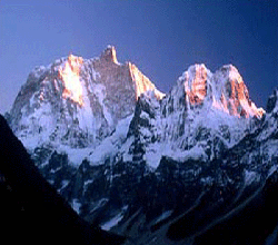
In addition to the main peak of kanchenjunga trekking, four subsidiary summits exceed 8000m, the most important being Kangchenjunga West, also known as Yalung Kang (8,505m). Of some twenty peaks exceeding 7,000m, the highest are Kambachen (7,903m), Jannu (7,710m), Jongsong (7,483m), Kabru (7,353m), Tent Peak (7,365m) and the Twins (7,350m). There are numerous impressive peaks over 6,000m which would have merited greater interest had they not been amongst such prodigious company.
This great cluster of peaks is highly glaciated and cradles five major glacial systems. Three of these, the Zemu, Talung, and Rathong, lie to the east of the massif and flow into Sikkim , eventually feeding the mighty Tista river. In Nepal , to the west, the Kangchenjunga and Yalung glaciers form the major sources of the Tamur river.
The intense glaciation is caused by the very high levels of precipitation to which Kangchenjunga is subjected. The combined effects of its considerable height and isolated location, south east of the main Himalayan chain, leaves it totally exposed to the full force of the advancing monsoon originating in the Bay of Bengal in early June.
Even when the monsoon finally withdraws towards the end of September, Kangchenjunga is slow to lose its veil of cloud and submit to the drier and more settled weather patterns of Autumn.
When much of the Greater Himalaya remained hidden beyond borders closed to outsiders, access to Kangchenjunga was only possible through British-controlled pre-partition India and the mountain's eastern aspect became a familiar sight to visitors to Darjeeling . The situation changed little when Nepal ended its self-imposed isolation in 1950 because it refused to grant access to Kangchenjunga to more than a handful of mountaineering expeditions. Only since 1988 have a limited number of commercialised trekking parties been allowed to explore the mountain's immediate environs.
Such restrictions have undoubtedly made a significant contribution to the preservation of the region's flora and fauna. Eastern Nepal and much of Sikkim are of great interest to the botanist and many new species are still being discovered in the vast forests and remote valleys.
Cultures of kanchenjunga trekking also have been preserved. Tibetan Buddhism is the most important religion in Sikkim and there are numerous monasteries dotted throughout the hills. In contrast, Hinduism is the main religion on the Nepal side of the border, where the tiny hill villages are inhabited by Rai and Limbu farmers.
| Itinerary in Detail | |
| Day 01 | ARRIVE KATHMANDU mid-afternoon. Our airport representative will meet you at Tribhuwan international airport and transfer to hotel . |
| Day 02. | KATHMANDU Free day in to relax, explore, rest more etc. Have dinner with the rest of the group to get acquainted. |
| Day 03 | FLY TO BIRATNAGAR. An exciting flight over the foothills of the Nepalese Himalaya, with views of the main peaks to the north. You will be met at Biratnagar by your Sherpa crew and the porters and will transfer to a local hotel. |
| Day 04 | FLY TO TAPLEJUNG, (5,900ft). TREK TO TABAWA, (6,562ft). Another exciting flight over the foothills. Taplejung has cobblestone streets, government offices, a police post and a small hospital. It is the hub of this region and there is a bazaar on a Saturday. Walking north of Taplejung, the Tamur river diverges; from here either of its tributaries, the Ghunsa or Simbua Khola, can be followed to the Kangchenjunga or Yalung glaciers respectively. You will take the route first to the southern Base camp and then cross high passes to reach the north base camp. After a look around the bazaar the trail out of Taplejung passes a large water reservoir and negotiates an unusually steep climb to the airfield again, which is situated on a ridge high above the village. Beyond the airfield the climb eases and becomes a pleasant ridge route passing through grassy meadows into a forested area. There is a descent to Lal Kharka and then to the cultivated fields of Tabawa where camp can be made in the school grounds. |
| Day 05 | TREK TO KHESEWA. (6,900ft). 5 hours. The trail now makes a long circuitous descent of the mountainside to the terraced fields of Pokora where there is a suspension bridge over the Phawa Khola. Once again there is another long ascent to the banjyang high above, at first through fields, then forest and finally on a gently sloping mountain path. The climb is well worthwhile as the view from the banjyang reveals Kangchenjunga and her satellites in all their glory. It is now possible to identify the individual peaks of the mountain; Yalung Kang on the left, the main summit appears as a small pyramid, and the south summit as a ridge to the right. As always Jannu is an obvious tower well off to the left and slightly in front of the main group. The descent to Khesewa is on a gentle path and the views gradually disappear behind the intervening ridges as altitude is lost. Camp can be made in or near the village. This is truly marvellous country with line upon line of forested ridges providing a wonderful contrast and backdrop to the rich flora and cultivated fields of the valleys. |
| Day 06 | TREK TO MAMANKE. 6 hours. The trail continues its way up, down, over or around the great ridges on the west side of the Kabeli Khola crossing tributaries of the main river on the way. Often passing through terraced fields or forested areas, there is always the anticipation of further views of the high mountains appearing at any time. The one really good view is of Jannu from the ridge crest at Ponpe Dhara. Camp in fields near the sprawling village of Mamanke . |
| Day 07 | TREK TO YAMPHUDIN. (7,054 ft), 5 hours. More ups and downs on the hillsides above the Kabeli Khola until the trail descends some stone steps to the river itself. A gradual climb up to the ridge and then through fields brings you to the last permanent settlement, Yampdudin. There is a police checkpost here, and good camping can be found in fields beside the river on the south side of the village. |
| Day 08 | TREK TO LAMITE Jungle Camp (3 – -4hrs). Leaving the north side of Yamphudin the trail first crosses the Omje Khola before ascending a spur beside it. After many days walking through cultivated areas it is good, at last, to leave civilisation behind. There are excellent views back towards, and beyond, Yamphudin. The route up the spur leads to a high valley and subsequently to a broad grassy col high above. Reaching the col reveals the immense and unspoilt forests of the upper Omje Khola valley; There follows a wonderful and steady descent through birch and fir forest, often on a carpet of leaves and beneath branches swathed with lichen. The river is crossed once again on a small log bridge. There are camp sites here at 7,200 feet in the Lamite Jungle. |
| Day 09 | TREK TO TORONGTAN. (9,514 ft), 6 hours. From Lamite the trail begins a long ascent to cross the Deorali Danda ridge at a col of around 10,800 feet. The path winds it way uphill, steeply at first, through rhododendron thickets to a clearing at Chittre. This is another alternative campsite, though water is unavailable during the dry season. The col when reached is broad and contains a small pool. There are views to the north west of the summit of Jannu and Kangchenjunga reveals itself at several points on the descent to the Simbua Khola. The initial part of the descent from the ridge has been subject to landslide and requires care; the drop is considerable! The trail finally re-enters the forest for a pleasant and steady descent to the banks of the Simbua Khola. A walk of about half an hour along the bank leads to a small bridge which provides access to the north bank and a clearing known as Torongtan or Thorongding. |
| Day 10 | TREK TO TSERAM. (12,139 ft), 5 hours. The lower Lalung valley is thickly forested with pine and rhododendron and a good path follows the river north-east towards its source on the Yalung Glacier. Occasional delightful views of the snowy mountains can be seen ahead. The trail follows the ever-widening riverbed and becomes very easy. Eventually the terminal moraine of the Yalung Glacier comes into view, overlooked by the peaks of Talung, Kabru and Rathong. Tseram is a pleasant grassy campsite on a small terrace approx. 150 ft above the north bank of the river. |
| Day 11 | TREK TO RAMZE. (14,764ft), 6 hours. A steep moraine slope blocks the way out of Tseram; it is necessary to descend to the riverbed to avoid it. Beyond the trail enters a final short forested area to reach a single stone hut at Yalung Bara. The way ahead is so typical of the high valleys of Nepal as the path wanders its way along a shallow ablation valley with the great white mass of mountains dominating the view ahead. The glacier itself is finally revealed at Lapsang along with the Rathong La pass and the beautifully ice-fluted peak of Koktang . A glacial lake near Lapsang provides the perfect foreground to the high mountains beyond. The trail levels beyond Lapsang and it is a very pleasant and inspiring walk to Ramze, where camp can be made on the grassy pastures beside two small stone huts. |
| Day 12 | TREK TO OKTANG, (16,404ft), AND RETURN TO LABSANG. The last camp is at Ramze and from here you can make a further day excursion to obtain views of the south face of Kangchenjunga. Beyond Ramze the glacier turns north and this corner can be reached in about 1 hour from camp over fairly level and easy going ground. At the corner a tremendous view opens up to include the entire south and west sides of Kangchenjunga which have previously remained hidden during the later stages of the walk-in. In a further hour a small track leads onto the lateral moraine of the Yalung Glacier to a chorten from where there are unsurpassed views which include Kangchenjunga main summit, Yalung Kang and Kambachen Peak at the head of the valley. The trail then descends to the small clearing at Oktang from which further exploration will reveal the long north east ridge of Jannu. It is only about an hour from Ramze to Labsang and this will give you a good start for crossing the Mirgin La. |
| Day 13 | CROSS THE MIRGIN LA. (14,698ft), 8 hours. Crossing the double passes from Labsang to Ghunsa can be completed in two days without difficulty. From Labsang situated close to the snout of the Yalung Glacier, a path traverses around a wooded hillside to the tree line from where there is a rugged, steep ascent of some 2,000ft. At the top there is a spectacular overlook across the lower reaches of the Yalung Glacier towards the peaks on the Sikkim frontier. The trail then contours around a craggy hillside to reach the Sinelapcha La, 15,000 ft. From the wide saddle stretches the ‘Gendarme Cwm' dominated by an imposing tower of red rock. This leads to the Mirgin La, 14,700ft from where there are extensive views stretching from Jannu to Makalu . the path now descends from the narrow saddle and then leads round a succession of grassy cwms below small rock peaks to an excellent campsite in a ‘fairy meadow' at Boulder Kharka. Jannu is particularly impressive from here. |
| Day 14 | CROSS THE SINION LA, (13,287 ft), DESCEND TO GHUNSA. 6 hours. Cross the narrow rocky breche of the Sinion La and follow the southern flank of the ridge on a good trail with superb views to the Tama Lase La, 12,795 ft. , on the shoulder of the ridge. A long descent now follows of 1,300ft. , through beautiful forest to a clearing on the lip of the Yamatori valley. Continue descending through pine and rhododendron forest to Ghunsa. There is a small Tibetan monastery here and Ghunsa is a well-kept village of some thirty stone houses, plus a police post. There is an excellent campsite in open woodland a little beyond the village. |
| Day 15 | TREK TO KAMBACHEN, (13,123ft), 5 hours. The trail now follows the floor of the valley beside the blue green waters of the infant Ghunsa Khola through scrub rhododendron and juniper. The terminal moraine of the Jannu glacier can be seen clearly ahead, although there is only ever the occasional glimpse of a snow-covered peak. As the moraine is reached a small bridge gives access across the river to a tiny grassy clearing known as Rhambuk Kharka. The slopes above here are subject to landslide and rockfall and great care is needed to negotiate a steep traverse across one very large affected area. The views to the north and east gradually open out to include the peaks of Phole, Sobithonge and Jannu rising majestically above the moraines of the Jannu Glacier. Beyond the landslide the trail levels, traverses the hillside and finally descends to the small summer settlement of Kambachen. Jannu is hidden from view at Kambachen, but the Sharphu group is now visible at the head of the valley. Broad fields provide plenty of useful campsites and there are huts for the porters. |
| Day 16 | REST DAY. It is worth taking an extra day at Kambachen to give the porters time to prepare for the walk-in to base camp, and for trekkers to ascend the hill above the village for stunning views of Jannu. (Optional walk toward Jannu Base Camp). |
| Day 17 | TREK TO LHONAK. (15,354ft), 6 hours. The rough but easy trail continues up the west bank of the river, first across a small boulder field and then up a short but easy snow slope to the level kharka of Ramtang. The view ahead becomes increasingly impressive but attention is drawn to the upper reaches of the Ramtang Glacier which feeds off Kambachen, the mighty western outlier of the Kangchenjunga massif. Another hour of level walking leads to the snout of the Kangchenjunga Glacier across whose moraines rise Pyramid Peak , Tent Peak , and Nepal Peak at the head of the valley. The terminal moraine and the river from the Lhonak Glacier enter from the north but present only a minor obstruction to access onto the level sandy and grassy plains at Lhonak. It can be a windy spot so the best campsite is on the grass close to the hillsides. There are wonderful mountain views in all directions with the ice flutings of Wedge Peak and the snowy ramparts of Nepal and Tent Peaks presenting the ideal backdrop for a colourful sunset. |
| Day 18 | TREK TO PANGPEMA. (16,502 ft), 4 - 5 hours. The route to Pangpema from Lhonak is on a deceptively-rising track which follows a shelf alongside the lateral moraine of the Kangchenjunga Glacier. The views are stunning as progress is made up the valley with Wedge, Nepal, Tent and Pyramid Peaks all developing themselves, along with the Sharphu peaks dominating the horizon down the valley. As Pangpema is reached the view to the south open up to reveal the Twins and, finally, the great north faces of Kangchenjunga and Yalung Kang. the location of Pangpema on a small grassy shelf above the glacier, is stimulating and the panoramic views quite stunning. Prayer flags adorn a large boulder and there is a small plaque in memory of the American climber, Chris Chandler. |
| Day 19 | REST DAY, LOCAL EXPLORATION AND SHORT WALK BACK TO LHONAK. (15,354ft), 2 hours. Time for washing, relaxing and enjoying the atmosphere at Kangchenjunga's north base camp. You may well walk back to Lhonak to make the following day easier. |
| Day 20 | RETURN TREK TO KAMBACHEN. (13,123ft), 4 hours. |
| Day 21 | TREK TO KYAPRA. (8,661ft), 7 hours. Back down through the stark mountainous scenery past Ghunsa and on for another three quarters of an hour to Phole, where the valley narrows. It now becomes forested and the trail keeps to the west bank of the Ghunsa Khola. There is a good campsite at a small clearing at Kyapra beside a cluster of Buddhist stone huts. |
| Day 22 | TREK TO TANGEP. (5,577ft), 4 or 5 hours. This is a day of many ups and downs as the trail stays close to the bed of the Ghunsa Khola with its many fine waterfalls and deep pools. The vegetation slowly changes as the altitude decreases and the trail penetrates dense forests of bamboo, fir and scattered rhododendron. Arrive at some clearings known locally as Tangep to camp. |
| Day 23 | TREK TO SAKANTHON. (5,577ft), 4 hours. Follow along a steep and twisting path, around an obvious corner in the valley to the small village of Amjilassa . The steepness of the hillside has relented here enough to allow some cultivation. The view down the valley now is stunning; the distant Ghunsa Khola snakes like a silver ribbon against the backdrop of the steep cliffs. There is a spectacular traverse past several waterfalls on a narrow but well engineered path. From the rocky traverse a steep descent is made into the deep, narrow and steep sided valley. There is a small campsite on a grassy shelf above the river. |
| Day 24 | TREK TO SINWA. (3,576ft), 5 hours. After half an hour cross a bridge and reach the confluence of the Ghunsa Khola. The valley sides are steep and the path traverses high above the Tamur river. The small village of Helok is located at the confluence of the Tamur River with the Simbua Khola and there is a good bridge across the north bank. In the heat of the afternoon it is tempting to camp at one of the many clearings beside the river but you should press on through the beautiful rock gorges across steep forested hillsides, past the village of Chiruwa to camp on grass beside the river near the village of Sinwa . |
| Day 25 | TREK TO DOBHAN. (2,650 ft), 4 hours. This is an easy day's walk beside the Tamur River through numerous paddy fields. Cross the large suspension bridge to the village of Dobhan . There is a large campsite at Dobhan beside the bridge. The village is fairly busy with a line of well-stocked shops. A hydro electric scheme now supplies power to the village. |
| Day 26 | TREK TO TAPLEJUNG. Beyond the bridge over the Tamur River the trail splits and the right hand branch begins a long zig-zag course up the hillside to Taplejung. Camp as before. |
| Day 27 | FLY TO KATHMANDU VIA BIRATNAGAR. Return to ‘civilisation' full of a profound sense of achievement and longing for a hot bath, a beer, and some of the Kathmandu Guest House's excellent food. Met on arrival and transferred to the Kathmandu Guest House. |
| Day 28 | AT LEISURE IN KATHMANDU . Time for shopping, relaxing, writing the postcards you forgot to send, and catching up with your diary. Overnight at the Kathmandu Guest House. |
| Day 29 | Depart Kathmandu to your destination. |
| Price USD 2800 per person (Single Supplement USD 420) | |
| Price includes: | Airport Pick up/drop, 4 nights accommodation in kathmandu at tourist standard hotel, , all inclusive trek such as Ground transportation, necessary permits ( including special permit), entrance fess, professional guide, porter/porters, and their expenses including their insurance and equipments, accommodation in the Guest house, all food (breakfast, lunch & dinner) with tea/coffee, soft drinks, domestic flights etc. |
| Price excludes: | Alcoholic drink, Tips, your insurance, personal/natural expenses, Food the cites. |
![]()
![]()
![]()
![]()
![]()
![]()
![]()
![]()
![]()